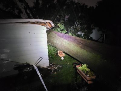
Wind gusts as high as 84 miles per hour brought down trees and power lines in the western Ozarks late Saturday night into early Sunday morning, while several stranded motorists had to be rescued in the city of Springfield from flash flooding.
What We Know: Multiple trees and power lines are down in parts of the Ozarks, including the cities of Joplin, Duenweg, and Carthage and Webb City. Numerous power lines were downed across the city of Joplin. A front porch was blown off a house in Fidelity west of Apple Road and I-49 in Jasper County. Large tree limbs were down on a house at 2nd and Webb in Webb City, with multiple trees uprooted in Webb City and north Joplin. Butterfield fire responded to power lines down at Highway 37 and Highway U. We had reports of trees down, building damage and powerlines down all up and down Highway J between Diamond and Wentworth. A power outage was reported in downtown Branson.
What We Don’t Know: While there were several tornado warnings issued for areas west of Springfield late Saturday night into early Sunday, those were all based on radar-indicated rotation. We’ve not had reports of any tornado touchdowns, but the National Weather Service will survey whether storm damage was from straight line winds or tornadoes.
Highest Wind Gust: The National Weather Service says an 84 mile per hour wind gust was measured on Ridgewood Road in Neosho at 11:45pm Saturday. Other wind gusts of 70 + miles were reported in the western Ozarks. Multiple trees and power lines have been reported down in Neosho.
Dangerous Situation for Drivers: Heavy rains training over the same areas led to Flash Flood Warnings being issued for a number of counties in the Ozarks. Flooding in Greene County has prompted numerous water rescues and stranded vehicles. The Highway Patrol reported motorists stranded in water in their vehicles near St. Louis and Glenstone.
Information on Flooded Roads: Find out where flooding has closed roads in southwest Missouri and across the state with the MoDOT Traveler Information Map.
(Photo courtesy of Doug Baker—Taney County Skywarn via NWS Chat).