
UPDATE: 4:45 A.M. Sunday: The remaining counties have been cancelled from the Tornado Watch. Severe thunderstorms are possible again Sunday afternoon and evening, with a Level 3 “enhanced risk” for severe storms along and south of a line from Joplin to Springfield, to Houston. Half dollar size hail, damaging winds up to 70 miles per hour, and a tornado or two are all possible.
UPDATE: 4:30 A.M. Sunday: A Flash Flood Warning for St. Clair County will expire at 4:30 a.m. Sunday. The National Weather Service says flooding is no longer expected to pose a threat, but you should continue to heed remaining road closures.
UPDATE: 4:22 A.M. Sunday: The Severe Thunderstorm Warning for Hickory, Polk, eastern Cedar and eastern St. Clair Counties has been allowed to expire. The National Weather Service says the line of storms continues to weaken and the Tornado Watch is being cancelled for areas where the line has moved through, which is primarily west of Springfield. The Tornado Watch remains in effect for areas along and east of Highway 65 through 7:00 a.m.
UPDATE: 3:45 A.M. Sunday: The National Weather Service has cancelled the Tornado Warning for southeastern Cedar County. The storm that prompted the warning has weakened below sever limits, and has exited the warned area. A Severe Thunderstorm Warning is in effect until 4:15 a.m. for Hickory, eastern Cedar, Polk and eastern St. Clair County. 60 mile per hour wind gusts are the main threats as the storm moves through Bolivar, Humansville, Osceola, Polk, Fair Play, Hermitage, Weableau, Morrisville, Wheatland, Preston, Cross Timbers, Halfway, Collins, Flemington and Roscoe.
UPDATE: 3:37 A.M. Sunday: The Tornado Warning for Dade County has been allowed to expire at 3:30 a.m., but a Tornado Warning is now in effect for southeastern Cedar County until 4:00 a.m. Sunday. A severe storm capable of producing a tornado was located near Stockton at 3:25 a.m., moving northeast at 30 miles per hour. This is radar-indicated rotation. The storm will be impacting Stockton Lake, the city of Stockton and Bearcreek.
UPDATE: 3:08 A.M. Sunday: The National Weather Service has issued a Tornado Warning for central Dade County until 3:30 a.m. Sunday. At 3:07 a.m., a severe thunderstorm capable of producing a tornado was located over Lockwood, or near Greenfield, moving northeast at 35 miles per hour. This is radar indicated rotation. Locations impacted include Stockton Lake, Greenfield, Lockwood, Dadeville, south Greenfield, Neola, and Bona.
UPDATE: 3:06 A.M. Sunday: The National Weather Service has issued a Severe Thunderstorm Warning for Cedar and Dae Counties until 3:45 a.m. Sunday. At 3:03 a.m., severe thunderstorms were located along a line extending from 12 miles west of Stockton to 8 miles northwest of Greenfield to near Lockwood, moving northeast at 35 miles per hour. The storms are capable of producing 60 mile per hour winds and penny size hail.
UPDATE: 3:01 A.M. Sunday: The Severe Thunderstorm Warning for Newton, McDonald and southern Jasper Counties is being allowed to expire at 3:00 a.m. Sunday. The National Weather Service says the storms that prompted the warning have weakened below severe limits and have exited the warned area. The line of storms moving through southern Missouri has weakened for the most part, but winds of 50 to 55 miles per hour will be possible as the storms move through eastern Barton, eastern Newton, eastern McDonald, Barry, Lawrence, eastern Jasper and Dade Counties through 3:45 a.m.
UPDATE: 2:35 A.M. Sunday: The National Weather Service has allowed a Tornado Warning for McDonald County to expire. The storm has weakened below severe limits. A Severe Thunderstorm Warning is in effect for Newton, McDonald and southern Jasper Counties until 3:00 a.m. 70 mile per hour winds and penny size hail are possible in Joplin, Carthage, Neosho, Webb City, Granby, Carl Junction, Anderson, Noel and Sarcoxie.
UPDATE: 1:25 A.M. Sunday: The line of severe storms in eastern Kansas and northeast Oklahoma is making its way into southwest Missouri. The National Weather Service has issued a Severe Thunderstorm Warning for Newton and Jasper Counties until 2:15 a.m. Sunday. The storms are capable of producing 60 mile per hour winds and penny size hail as they move through the Joplin, Carthage, Webb City, Carl Junction, Seneca, Granby, Sarcoxie and Jasper.
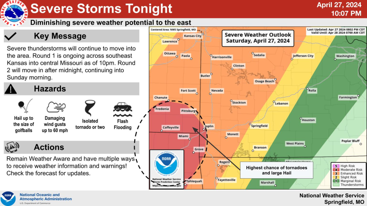
UPDATE: 12:25 A.M. Sunday: We’ve had several Severe Thunderstorm Warnings and Tornado Warnings Saturday night for areas north and west of Springfield. Severe storms in Oklahoma are quickly developing into a line and moving east into our area overnight Sunday morning. The line will mainly impact areas west of Highway 65 between 2 and 7 a.m. Sunday. Main hazards with this line will be wind gusts up to 70 miles per hour, but forecasters can’t rule out hail up to the size of golf balls and a tornado or two. A new Tornado Watch is in effect for most of southwest Missouri, including the Springfield Metro Area, until 7:00 a.m. Sunday.
UPDATE: 5:00 PM: The National Weather Service has issued a Tornado Watch for Barton, Cedar, Dade, Hickory, Jasper, St. Clair and Vernon Counties until 12:00 a.m. Sunday. Conditions are favorable for the development of tornadoes, along with hail up to the size of baseballs and damaging wind gusts up to 70 miles per hour.
The National Weather Service says significant and dangerous severe weather is expected Saturday night in areas along and west of Highway 65, with the greatest potential focused along and west of Interstate 49 in the western Ozarks.
Forecasters say tornadoes, potentially EF2+, hail to the size of baseballs, and wind gusts up to 70 miles per hour are all possible.
In addition, significant and dangerous flooding is expected in areas along and west of 65 as additional heavy rain impacts the area Saturday evening into Sunday morning. A Flood Watch is in effect for much of the Ozarks from 7pm Saturday to 1pm Sunday.
The city of Joplin and areas along and west of I-49 are under a level 4 out ot 5 “moderate risk” for severe weather, where the potential exists for very large hail up to the size of baseballs, damaging winds of 70 miles per hour, strong tornadoes and flash flooding.
Areas just west of Springfield are under a level 3 “enhanced risk” of severe weather.
The Springfield Metro area south to Branson and north to Lebanon and Rolla are under a level 2 “slight risk,” with the far eastern Ozarks under a level 1 “marginal risk” for severe storms.
Forecasters say there may be an earlier round of storms form Saturday afternoon east of Highway 65, but it remains unclear if they even develop. If they do develop, then they could be severe.
After 8 pm Saturday, the main severe threat ramps up, mainly along and west of I-49. Storms that form in eastern Oklahoma will quickly move northeast into our listening area along the Missouri/Kansas border by 8-10 pm. Forecasters say these will quickly become a southwest to northeast-oriented band of supercells with bow structures, bringing the threat of all significant hazards.
The weather service says these supercells will be training, so after one supercell moves through the area, there is still the potential for another, with the same hazards, to move over the same location. Keep this in mind when making your safety plans.
Another line of storms will develop across Kansas and Oklahoma, then slowly progress eastward through the Ozarks. This would bring the severe threat to the Springfield area by early morning, between 1 and 4am Sunday.
All hazards will be possible with this line of storms, including tornadoes and wind gusts up to 70 miles per hour. Hail will still be possible, but less likely.
The storms should be weakening and pushing out of our area by 3am.
Additional rainfall amounts of 2-4 inches will be possible from Saturday night through Sunday, and this will likely cause significant flash flooding and river flooding, especially over areas that have seen heavy rain lately.
Nighttime flooding is especially dangerous. Turn around, don’t drown!
The National Weather Service says if enough heating develops on Sunday, then additional thunderstorms will redevelop Sunday afternoon and evening, and some may be severe.
Confidence is low with this severe threat on Sunday, and all of the Ozarks is under a level 2 “slight risk” for severe weather.
Stay tuned to 93-3 and A-M 560 KWTO for forecast changes, along with all the watches and warnings. We’ll have live, in studio updates and damage reports as the storms move through.