UPDATE at 5:15 p.m. Thursday: A Flash Flood Warning remains in effect for Greene County until 7:00 p.m. Thursday. The National Weather Service says as of 3:24 p.m., between 1 and 3 inches of rain had fallen, with reports of significant street flooding during the 2 p.m. hour along Lone Pine Avenue near Pearson Creek. There were reports of flooding on the roads in the Galloway area, with some roads impassable just northwest of Springfield due to heavy rainfall occurring around 3:30 p.m. The warning does include Springfield, Republic, Battlefield, Strafford, Willard Ash Grove, Fair Grove, Walnut Grove, Brookline, Glidewell, Ebenezer, Cave Springs, Sacville, Galloway, Bois D’Arc, Turners and Bassville.
The rest of the Flash Flood Warnings listed below have been allowed to expire at 5:00 p.m. as heavy rain has come to an end in those areas.
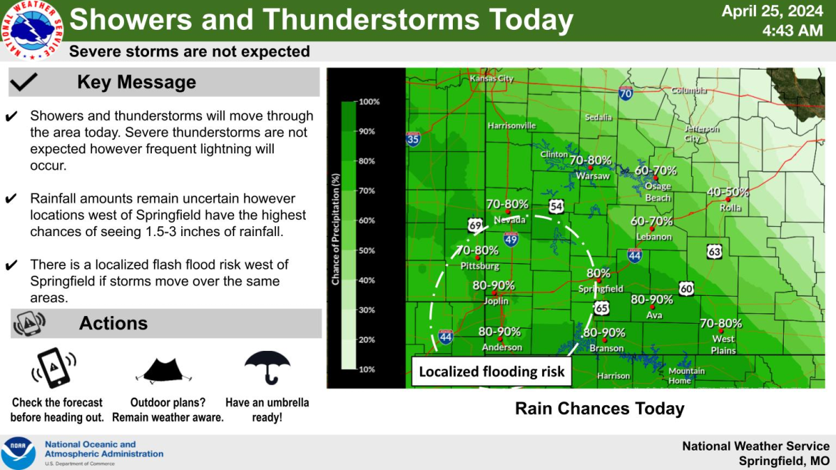
Multiple rounds of showers and thunderstorms will move through the Ozarks Thursday through Sunday, with the potential for severe storms beginning Friday.
Round one is well underway, with flash flooding to the west of Springfield. The National Weather Service says while no severe weather is expected with this round, frequent lightning will occur.
By late Thursday morning, we had reports of nearly five and a half inches of rain northeast of Carthage. The weather service says between 3 and 6 inches of rain have fallen in southeastern Jasper County and southwestern Lawrence County, who are both under a Flash Flooding Warning until 2:45 p.m. Thursday.
Forecasters say life-threatening flash flooding of creeks and streams, urban areas, highways, streets and underpasses is occurring.
A Flash Flood Warning is in also effect until 5:00 p.m. Thursday for central Jasper County, including northern Joplin, Carthage, Webb City, Oronogo, Carterville, Alba, Purcell, Carytown, Asbury, Avilla, Brooklyn Heights and Waco, and a Flash Flood Warning goes until 3:30 p.m. Thursday for Lawrence County, including Aurora, Mt. Vernon, Marionville, Miller, Verona, Stotts City, Halltown, Freistatt, La Russell, Hoberg and Chesapeake.
The Lawrence County 911 Center has reported two water rescues in the Mt. Vernon area, including one off of Interstate 44, and the other near Alice and Landrum.
We’ve also had reports of a tree down across Kafir and State Highway 171 that has caused a wreck.
A Flash Flood Warning is also in effect for central Christian and northern Stone Counties until 5:00 p.m. Thursday.
The weather service says by 1:00 p.m., between 2 and 4 inches of rain had fallen, with another 1 to 2 inches possible in southern Springfield, Nixa, Ozark, Highlandville, Clever, Crane, Billings, Fremont Hills, Hurley, Spokane, Boaz, Ponce de Leon, Selmore, Chestnutridge, Christian Center, Elsey and Linden.
By Friday afternoon and evening, forecasters say thunderstorm coverage will likely be low, but if storms do form, they could produce hail up to the size of golf balls, damaging wind gusts, and tornadoes.
For Saturday, the highest potential for severe storms will be west of our area in southeastern Kansas.
Meteorologists say storms that are able to move in from the west could produce large hail, damaging winds and tornadoes. While those storms could move into southwest Missouri during the afternoon and evening, the highest chances of them occurring are Saturday night.
Then on Sunday, the entire area has a risk for large hail, damaging winds and tornadoes. Severe storms could be ongoing during the morning, with additional development during the afternoon if enough heating develops behind the morning storms.
We’ll have the latest forecast updates, plus all the watches and warnings issued by the National Weather Service, on 93-3 and A-M 560 KWTO.