
2:30 p.m. UPDATE: The National Weather Service has cancelled the Severe Thunderstorm Watch for many counties in the Ozarks. The watch is still in effect until 4:00 p.m. for Barry, Barton, Jasper, Lawrence, McDonald, Newton, and Howell Counties.
1:25 p.m. UPDATE: The National Weather Service has allowed the remaining two Severe Thunderstorm Warnings to expire. The cell in central Douglas County has collapsed, so that warning is expiring at 1:30 p.m. The warning for Taney County is also expiring at 1:30 p.m. because the storms that prompted the warning have weakened below severe limits. A Severe Thunderstorm Watch remains in effect until 4:00 p.m. Sunday for all of southwest Missouri.
1:07 p.m. UPDATE: We have reports of a tree and power line down on Highway 76 at Kirbyville and another tree down at 76 and T Highway.
12:50 p.m. UPDATE: The National Weather Service has issued a Severe Thunderstorm Warning for central Douglas County until 1:30 p.m. A severe storm was located near Mansfield, moving southeast at 40 miles per hour. 60 mile per hour winds and quarter size hail are possible in the Ava, Vanzant, Drury and Gentryville areas. Quarter size hail being reported on Highway 5 and 76 in the Ava area.
12:38 p.m. UPDATE: The Aurora Rural Fire Department is responding to power poles down in the area of Lawrence 1200 and 2240, just south of Aurora. The Highway Patrol is on scene assisting with traffic control.
12:34 p.m. UPDATE: The Severe Thunderstorm Warning for southeastern Webster County has been cancelled. The storm that prompted the warning has weakened below severe limits.
12:30 p.m. UPDATE: The National Weather Service has issued a Severe Thunderstorm Warning for Taney County, southeastern Christian County and southeastern Stone County until 1:30 p.m. 60 mile per hour winds and quarter size hail are possible in the Branson, Forsyth, Taneyville, Kirbyville, Hollister, Blue Eye and Rockaway Beach areas.
12:23 p.m. UPDATE: Heavy wind is reported on the James River arm of Table Rock Lake near Shell Knob and Golden. Trees are down. We’ve had reports of 50 mile per hour winds and half inch hail in the Shell Knob area.
12:00 p.m. UPDATE: The National Weather Service has issued a Severe Thunderstorm Warning for southern Webster County until 12:45 p.m. A severe thunderstorm is located near Fordland, moving southeast at 20 miles per hour. 60 mile per hour winds and quarter size hail are possible as the storm moves into the Seymour and Diggins areas.
11:53 a.m. UPDATE: We’ve had reports of a power line down along a road three miles southeast of Aurora. Quarter size hail has also been reported in the Aurora area.
11:39 a.m. UPDATE: The National Weather Service has issued a Severe Thunderstorm Warning for western Taney County, south central Christian County, southeastern Stone County and southern Barry County until 12:30 p.m. Golf ball size hail and 70 mile per hour damaging winds are possible with this storm, moving into the Highlandville and Reeds Spring areas around 11:50 a.m., Kimberling City, Silver Dollar City and Branson West around 11:55 a.m., Branson around Noon, Forsyth, Merriam Woods, and Rockaway Beach around 12:10 p.m. and Hollister around 12:15 p.m. Lake Taneycomo, Table Rock Lake, Roaring River State Park, and Table Rock State Park are all in the path of this storm.
11:35 a.m. UPDATE: The National Weather Service says as this storm moves into the Table Rock Lake region, wind gusts up to 70 miles per hour and hail the size of golf balls will move over the lake by 12:00 p.m. to 12:15 p.m.
11:27 a.m. UPDATE: The National Weather Service says the best severe wind potential should be with the leading edge of the bowing segment between Verona and Aurora. Storms are quickly moving southeast at 40 miles per hour. The wind potential is being increased to 70 miles per hour with storms moving through the Monett area, and hail up to the size of golf balls is possible with the storm in the Aurora area. Quarter size hail has been reported by a National Weather Service employee one mile north of Monett at 11:24 a.m.
11:18 a.m. UPDATE: The Severe Thunderstorm Warning for Hickory, Dallas, western Laclede, northeastern Polk, Camden and parts of Benton, Miller and Morgan Counties has been allowed to expire at 11:15. The Storms that prompted the warning have weakened below severe limits. Gusty winds and heavy rain are still possible with these thunderstorms.
11:00 a.m. UPDATE: The National Weather Service has issued a Severe Thunderstorm Warning for northwestern Christian, southwestern Greene, eastern Newton, northern Stone, northern Barry and Lawrence Counties until Noon. These storms are extending from Everton to west of Mt. Vernon to near Carthage, moving southeast at 50 miles per hour. Two inch hail (over golf ball size) and 60 mile per hour winds will be possible in Republic, Monett, Battlefield, Marionville, Crane, Purdy, Wheaton, Aurora, Mt. Vernon, Clever, Pierce City, Billings, Verona, and Galena.
We’ve had reports of large tree branches down on Highway 96 between Avilla and Miller, as well as dime size hail reported at Miller High School around 11:00 a.m.
Original Story:
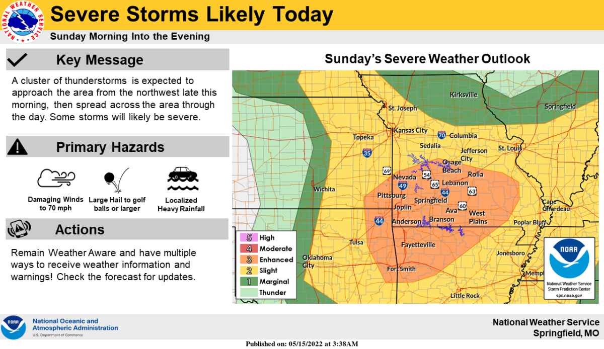
Severe thunderstorms are moving through southwest Missouri, firing up mid-morning Sunday.
All of southwest Missouri is under a Severe Thunderstorm Watch until 4:00 p.m.
The main threats will be large hail up to the size of ping pong balls, and damaging winds of 60-70 miles per hour.
A Severe Thunderstorm Warning has been issued for northwestern Lawrence, Jasper and Dade Counties until 11:15 a.m.
These storms are moving southeast at 25 miles per hour and are capable of producing 60 mile per hour winds and half dollar size hail as they track across Stockton Lake and through the cities of Webb City, Sarcoxie, Lockwood, Miller, Everton and Stotts City.
A Severe Thunderstorm Warning is in effect until 11:15 a.m. for Hickory, Dallas, Benton, western Laclede, Polk, southeastern St. Clair, and Camden Counties.
Quarter size hail and 60 mile per hour wind gusts are possible with those storms north and east of Springfield as they push across Lake of the Ozarks, Pomme De Terre Lake, Truman Lake, and the communities of Lebanon, Bolivar, Buffalo, Camdenton, Stockton and Warsaw.
We’ve had reports of damage in Hickory County around Pittsburg, with roof damage to a metal building with a tin roof and power lines down near the intersection of Highway 64 and Highway J.
Half dollar size hail was reported in the Barton County community of Oakton with storms that moved through there just after 10:00 a.m. Sunday.
We’ll have the latest warnings, as well as wind, hail and damage reports on 93-3 A-M 560 KWTO.