
The National Weather Service has issued a Winter Weather Advisory for much of the Ozarks, including the Springfield Metro Area, from 6am-6pm Tuesday.
Forecasters say total snow accumulations up to two inches are expected, with winds gusting as high as 40 miles per hour. Plan on slippery road conditions, and the hazardous conditions could impact the Tuesday morning and evening commutes.
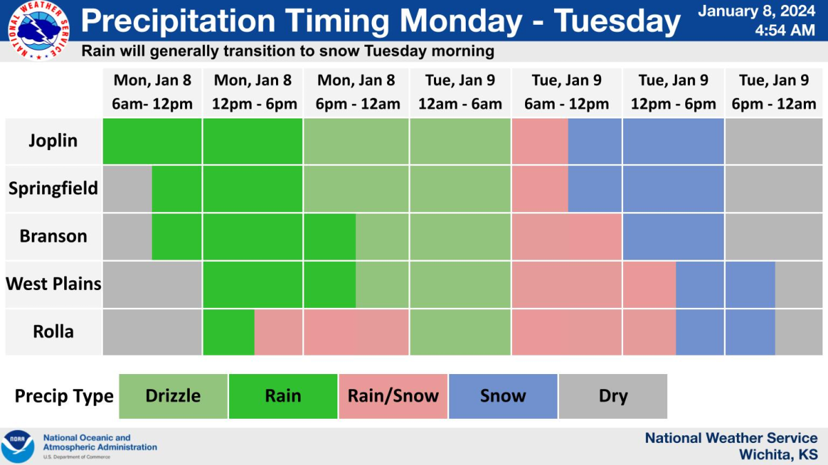
Parts of the Ozarks have already have had a mix of rain, sleet and snow Monday as temps decrease and strong winds filter into southwest Missouri.
Emergency managers and fire and rescue personnel reported sleet around 10:00 a.m. in the Indian Point area, with a sleet-rain mix in Branson, moderate rain with a snow mix east of Joplin in Duenweg, sleet southeast of Marshfield, and even trees down from high winds in the Brighton area. Law enforcement reported snow at Ozark Correctional Center in Fordland.
Webster County Emergency Management had reports of a snow/rain mix with big flakes in Marshfield around 11:30 a.m., while emergency managers in Hickory County reported a rain/snow mix and 37 degrees east of Preston just before noon, with strong wind gusts.
The National Weather Service says a Wind Advisory remains in effect for much of southwest Missouri until 4:00 p.m. Monday, with winds out of the southeast at 20 to 30 miles per hour. Some gusts could be up to 45 miles per hour.
Forecasters say by late afternoon and early evening Monday, the wintry mix will likely remain confined to central Missouri, with up to one inch of accumulation across Benton, Morgan and Miller Counties.
Some of the rain Monday will be heavy at times, with 1/2 to 3/4 of an inch possible during the daytime hours.
Drizzle looks likely overnight across most of the Ozarks as the low moves in, and temps look to remain above freezing.
Meteorologists say on Tuesday, the low will life northeast out of the area, and colder air will wrap around the low, with rain transitioning to snow during the morning in the western Ozarks and into the remainder of the area during the afternoon.
Models continue to keep the majority of heavy snow to the north of the Ozarks, with accumulations ranging from a trace up to two inches in much of southwest Missouri.
The weather service says areas of central Missouri will have better chances of seeing amounts higher than two inches on Tuesday, but will likely remain at four inches or less.
We’ll have the latest weather updates on 93-3 and A-M 560, KWTO.