UPDATE: Multiple tornado warnings were issued for the Springfield Metro Area late Monday night, with several reports of tornadoes on the ground. Get the latest on damages here: Tornadoes Touch Down in the Springfield Metro Area Monday Night | 93.3 KWTO (933kwto.com)
UPDATE: The Webster County Tornado Warning has expired. Two separate Tornado Warnings have been issued for Laclede County.
UPDATE: 10:45PM: The National Weather Service issued a Tornado Warning for Northern Webster, Southern Dallas, Southwestern Laclede, Southeastern Polk, and Northwestern Greene. At 10:56 PM a confirmed large and extremely dangerous tornado was located near Fair Grove and 9 miles north of Marshfield.
A Tornado Warning was issued for Central Greene County. At 10:31 PM the National Weather Service confirmed a tornado was located near Willard and 8 miles north of Republic.
UPDATE: The National Weather Service says the Tornado Warning for northeastern Jasper and southwestern Dade Counties has been cancelled. The storm that prompted the warning has moved out of the area.
The National Weather Service says latest models suggest the environment is becoming even more supportive of severe weather and that trend looks to continue east of the current line. In particular, models are showing portions of Greene, Webster, Wright and Laclede Counties in the area of greatest concern
UPDATE: 9:45 PM: A Tornado Warning is in effect for southeastern Barton, northwestern Lawrence, northeastern Jasper and southwestern Dade Counties until 10:15 p.m. Monday. The National Weather Service says a severe storm capable of producing a tornado was located over Carthage, moving northeast at 40 miles per hour. This storm will impact Carthage, Lockwood Golden City and Avilla areas.
We’ve also had reports of a 67 mile per hour and a 72 mile per hour wind gust recorded in Joplin, along with a Jasper County deputy reporting a tree down at Highway 171/Highway 43 roundabout.
UPDATE: 9:29 PM: Severe Thunderstorm Warnings are now in effect for southern Barton, northern Newton and Jasper Counties to the west of Springfield until 10:15 p.m. 60 mile per hour wind gusts and quarter size hail are possible with these storms as they move through Joplin, Carthage, Neosho, Webb City, Carl Junction, Lamar, Granby, Sarcoxie, Jasper, Diamond and Golden City. In addition, a Severe Thunderstorm Warning is in effect until 9:45 p.m. for western Barton County, including the towns of Liberal and Mindenmines.
UPDATE: 8:45 PM: We have our first Severe Thunderstorm Warning from the second round of storms as a line moves in from eastern Kansas and northeastern Oklahoma. A Severe Thunderstorm Warning is in effect for northwestern Barton and southwestern Vernon Counties to the northwest of Springfield until 9:15 p.m. Monday. 60 mile per hour wind gusts and quarter size hail are possible as the storm moves through Nevada, Liberal, Sheldon and Bronaugh.
UPDATE: 8:30 PM: Our remaining Severe Thunderstorm Warnings for northwestern Laclede and Camden Counties has been allowed to expire at 8:30. The National Weather Service says the storms have moved out of the area or weakened below severe limits. However, round two is on the way. The weather service says an area of severe storms moving through eastern Kansas and northeastern Oklahoma are expected to move into far southwest Missouri between now and 10:00 p.m. Some of those storms in Oklahoma have been tornado-warned. The storms are expected to track generally along I-44 if they maintain strength and environmental conditions remain favorable.
UPDATE: 8:10PM: The National Weather Service is allowing the Tornado Warning for central Dallas and central Laclede Counties to expire at 8:15 p.m. (the warning had previously expired for east central Polk County). Forecasters say the tornado threat has diminished, but large hail and damaging winds remain likely and a Severe Thunderstorm Warning remains in effect for this same area until 8:30 p.m.
UPDATE: 7:50 PM: The National Weather Service has issued a Tornado Warning until 8:15 p.m. Monday for central Dallas, east central Polk and Laclede Counties. In addition to a tornado, baseball size hail is possible with this storm as it moves to the east at 50 miles per hour. This is radar-indicated rotation.
Just before 7:30 p.m. we had reports of egg size hail (up to 2.00 inches in diameter) just northeast of Bolivar reported by the fire department. Other reports include ping pong ball size hail (1.5 inches) northeast of Bolivar, 1.75 inch hail three miles west of Louisburg, golf ball size hail northwest of Bolivar, quarter size hail and 60 mile per hour winds at 7:20 p.m. southeast of Fair Play, and strong winds taking down a 12 to 14 inch tree in the Cedarville area, plus tree limbs down and shingles blown off west of Umber View Heights as the storm moved through Cedar County.
UPDATE 7:44 PM: Baseball size hail and 70 mile per hour winds are possible as a severe thunderstorm impacts Dallas, northeastern Polk and Laclede County, with a Severe Thunderstorm Warning in effect until 8:30 p.m. The National Weather Service says this is a destructive storm for Halfway, Buffalo and Lebanon.
UPDATE: 3:40 PM: The National Weather Service has issued a Tornado Watch until 11:00 p.m. for much of the Ozarks, including the Springfield metro area. Our far eastern counties are not included in the watch at this time. Laclede and Pulaski Counties are also under a Tornado Watch until 12:00 a.m. Large hail up to softball size, damaging wind gusts up to 80 miles per hour and tornadoes are all possible.
UPDATE: 1:40 PM Monday, 4/1: The National Weather Service says winds of greater than 70 miles per hour will be possible in the Ozarks as the severe weather moves through Monday night. There is still the threat for hail greater than baseball size and some tornadoes, including a potential strong tornado. Look for the worst of the storms to move through the Joplin area between 7-9 p.m. and the Springfield area between 8-10 p.m., with storms in our eastern counties 10 p.m. to midnight.
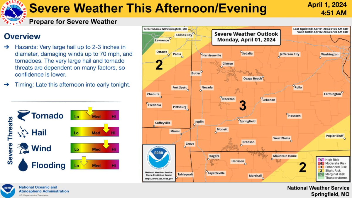
UPDATE: 6:45AM Monday, 4/1/24: All modes of severe weather are possible in the Ozarks on Monday, particularly in the late afternoon into the evening.
The National Weather Service says all of southwest Missouri is under a Level 3 out of 5 “enhanced risk” for severe weather.
The weather service says severe thunderstorms are highest between 4pm and 1am.
The severe hazards expected at this time are hail up to the size of baseballs to large apples, 70 mile per hour wind gusts, a few (possibly strong) tornadoes and a conditional threat for flash flooding.
The conditional threat for tornadoes, including strong ones, is greatest along and west of a line from Branson to Rolla, including the Springfield area.
The increase in confidence of having ample instability and in seeing supercells, have led to the increased tornado risk.
Forecasters say the threat is very conditional on storm mode and coverage. If storms develop into closely packed clusters or transition more quickly to linear, the tornado threat would be lower.
Forecasters say these threat levels may change over the next 24 hours as they get a better understanding of storm mode and evolution.
Areas generally along and east of Highway 65 have the best potential for a significant tornado.
There are low chances of severe thunderstorms beginning as early as Monday morning and early afternoon, which may decrease severe thunderstorm potential later in the day.
93.3 and A-M 560 KWTO will keep you up to date with the latest watches and warnings, as well as damage reports from the National Weather Service and local emergency managers.
Here’s the latest report from the National Weather Service on Monday’s severe weather.