We’ve had numerous severe thunderstorm warnings in the Ozarks starting Tuesday afternoon and continuing through the evening.
We’ve had reports of multiple trees and power lines down in the town of Jasper off to the west of Springfield, with quarter size hail reported earlier in the day in Springfield, golf ball size hail in Bolivar and ping pong ball size hail in Dallas County. Storms that moved through Highlandville and parts of Christian County Tuesday evening produced up to ping pong ball size hail.
9:10 P.M. UPDATE: Law enforcement is reporting trees and power lines down 1.5 miles north of Marionville on Highway 14. Pea to nickel size hail with heavy rain is being reported in Springfield.
9:00 P.M. UPDATE: The National Weather Service says at the moment, it is not planning further severe thunderstorms warnings as these storms continue to track east. Wind gusts of 50 to 55 miles per hour and penny size hail remain possible.
8:48 P.M. UPDATE: The National Weather Service has issued a Severe Thunderstorm Warning for western Christian, northern Stone and northeastern Barry Counties until 9:00 p.m. Severe storms were located along a line from Clever to southwest of Crane, moving southeast at 25 miles per hour. 60 mile per hour winds and quarter size hail are expected in Nixa, Ozark, Clever, Crane, Highlandville and Hurley.
8:47 P.M. UPDATE: The National Weather Service says up to 70 mile per hour winds are now possible with the storms moving through Springfield, Nixa, Ozark, Republic, Battlefield, Willard and Strafford.
8:34 P.M. UPDATE: The National Weather Service says 80 mile per hour winds are possible with a Severe Thunderstorm Warning issued until 9:00 p.m. for Greene County and northwestern Christian County. These are destructive storms for the Springfield area with tornado-like wind speeds expected. Mobile homes and high profile vehicles are especially susceptible to winds of this magnitude and may be overturned. For your protection, move into an interior room on the lowest floor of a building.
8:39 P.M. UPDATE: The National Weather Service is reporting a 78 mile per hour straight line wind gust at the Springfield-Branson National Airport.
8:24 P.M. UPDATE: Quarter size hail reported in Republic.
8:15 P.M. UPDATE: Quarter size hail is being reported in Walnut Grove with .25 inch hail.
8:10 P.M. UPDATE: The National Weather Service has issued a Severe Thunderstorm Warning for Greene County, western Christian, southwestern Dallas, northern Stone, Polk, northeastern Barry and southeastern Lawrence Counties. These storms are moving southeast at 35 miles per hour, and this is impacting the city of Springfield, as well as Nixa, Ozark, Republic, Bolivar, Aurora, Battlefield, Willard, Buffalo, Rogersville, Strafford, Marionville, Clever, Ash Grove, Crane, Fair Grove, Billings, Highlandville and Fremont Hills.
8:04 P.M. UPDATE: A Missouri State Highway Patrol trooper advised around 8:00 p.m. that warning sirens are going off in Pierce City. There is no tornado warning or immediate threat of a tornado. Some agencies activate their sirens because of high winds. As of 8:20 p.m., we are still getting reports that Pierce City and Monett have warning sirens sounding.
7:55 P.M. UPDATE: A Severe Thunderstorm Warning is in effect for a wide area west and north of Springfield, including western Hickory County, southeastern Barton County, northern Newton County, Cedar County, western Polk County, northwestern Barry County, Lawrence County, St. Clair County, eastern Jasper County and Dade County until 8:30 p.m. This line of storms is capable of producing 60 mile per hour winds and quarter size hail as it tracks through Carthage, Neosho, Ed Dorado Springs, Stockton, Greenfield, Sarcoxie, Pierce City, Appleton City, Humansville and Osceola. If you’re on Stockton Lake, Pomme De Terre Lake, or Truman Lake, get off the water until the storm passes through.
7:50 P.M. UPDATE: The National Weather Service has issued a Severe Thunderstorm Warning for south central Greene and north central Christian County until 8:30 p.m. At 8:30 p.m., a severe storm was over Nixa, moving north at 10 miles per hour. This storm is capable of producing 60 mile per hour wind gusts and quarter size hail as it moves through southern Springfield, Nixa, Battlefield and Fremont Hills.
7:45 P.M. UPDATE: A Severe Thunderstorm Warning is in effect until 8:15 p.m. for southwestern Greene and northwestern Christian Counties. 60 mile per hour winds and quarter size hail are possible as storms move through northwest Springfield, Republic, Billings, Brookline and Bois D’Arc.
4:40 P.M. UPDATE: The National Weather Service has issued a Severe Thunderstorm Warning for northwestern Dallas and eastern Hickory Counties until 5:15 p.m. Tuesday. A severe thunderstorm was located over Urbana, moving northeast at 25 miles per hour. 60 mile per hour winds and half dollar size hail are possible as the storm moves through Urbana and Preston.
4:10 P.M. UPDATE: The National Weather Service has issued a Severe Thunderstorm Watch for much of southwest Missouri, including the Springfield metro area, until 11:00 p.m. Tuesday. A line of storms is moving in from Kansas and will continue to push south into our area. Large hail and damaging winds will be the biggest threats.
4:00 P.M. UPDATE: The National Weather Service has issued a Severe Thunderstorm Warning for south central Hickory, northwestern Dallas, and northeastern Polk County until 4:45 p.m. Tuesday. At 3:57 p.m., a severe thunderstorm was located near Bolivar, moving northeast at 25 miles per hour. Ping pong ball size hail and 60 mile per hour wind gusts are possible as the storms move through Polk, Urbana, Louisburg, Goodson, and across Pomme De Terre Lake.
350 P.M. UPDATE: The National Weather Service says golf ball size hail has been reported in the Bolivar area.
3:33 P.M. UPDATE: The National Weather Service has issued a Severe Thunderstorm Warning for southeastern Polk County until 4:15 p.m. Severe storms were located along a line extending from near Morrisville to Pleasant Hope, moving north at 20 miles per hour. 60 mile per hour winds and quarter size hail are possible with the storms as they move through the cities of Bolivar and Halfway.
3:30 P.M. UPDATE: The Severe Thunderstorm Warning for northeastern Greene County is cancelled. The severe storm that prompted the warning has moved out of the area. A Severe Thunderstorm Warning remains in effect until 3:15 p.m. for southern Polk County. Trained weather spotters reported 60 mile per hour winds and quarter size hail with this storm.
3:15 P.M. UPDATE: The National Weather Service has issued a Severe Thunderstorm Warning for northern Greene County and southern Polk County until 3:45 p.m. 60 mile per hour winds and quarter size hail are possible as the storm moves through northwest Springfield, Willard, Ash Grove, Fair Grove, Walnut Grove, Pleasant Hope, Morrisville, Brighton and Eudora.
2:30 P.M. UPDATE: The National Weather Service has issued a Severe Thunderstorm Warning for Western Greene County until 3:15 p.m. Tuesday. A severe thunderstorm located near Republic is moving north at 20 miles per hour. 60 mile per hour winds and quarter size hail are the main threats with this storm as it moves through northwestern Springfield, Republic, Battlefield, Willard, Ash Grove and Brookline.
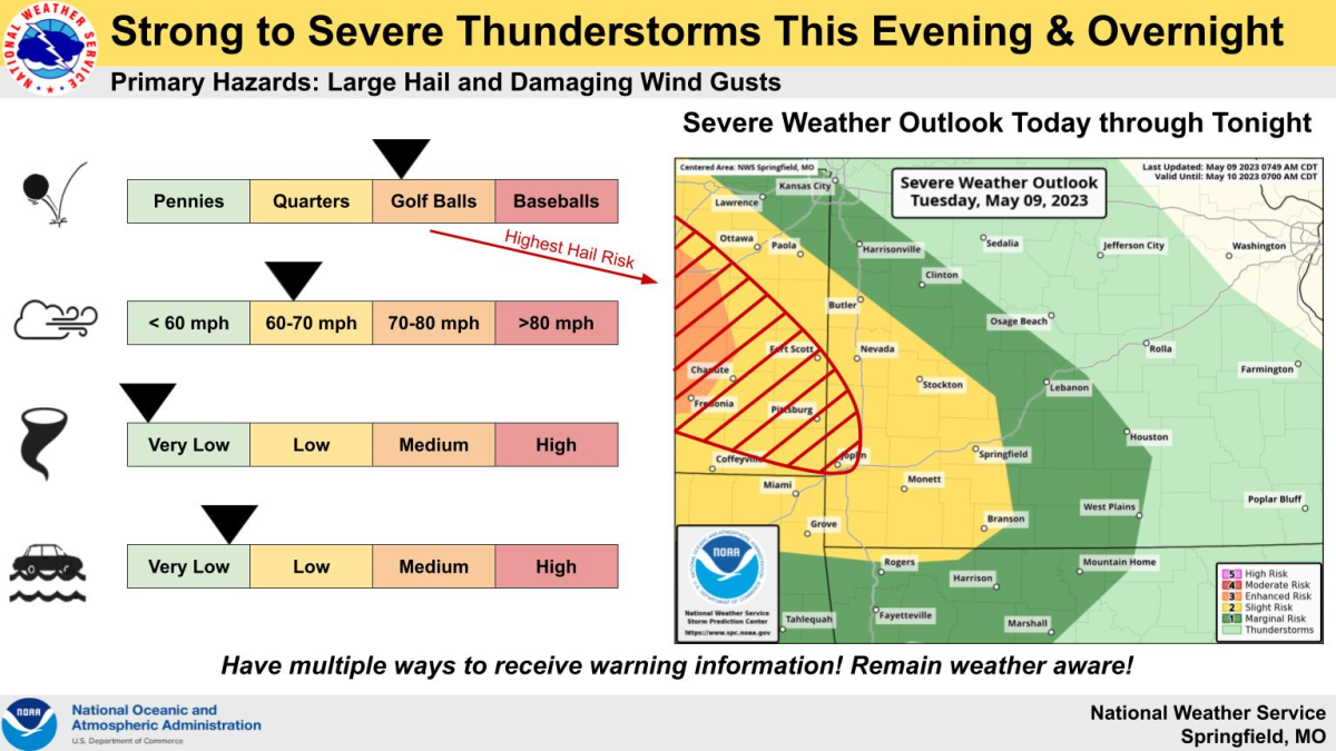
For the second day in a row, strong to severe thunderstorms are forecast for parts of the Ozarks Tuesday.
The National Weather Service says storms are expected to move through southwest Missouri starting sometime after 7 p.m., with the heaviest storms moving through the Springfield metro area around 1 a.m.
Forecasters say the highest risk for severe impacts will be west of Highway 65, where hail up to the size of golf balls and damaging winds will be possible with the strongest storms.
The tornado threat is very low.
Much of the area is under a Level 2 “slight risk” for severe weather, while the eastern Ozarks is under a Level 1 “marginal risk.”
We’ll keep you up to date on any watches and warnings issued by the National Weather Service on 93-3 A-M 560 KWTO.