
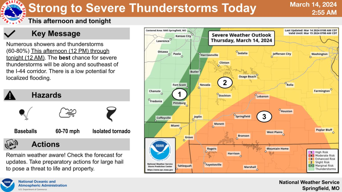
Numerous showers and thunderstorms will develop and move through the Ozarks Thursday afternoon through the evening.
The National Weather Service says areas along and south of I-44, including the Springfield Metro Area, are under a level 3 out of 5 “enhanced risk” for hail up to the size of golf balls to baseballs, wind gusts up to 70 miles per hour and an isolated tornado also possible.
Areas north of the interstate are in a level 2 “slight risk” for the same hazards.
There’s a low potential for localized flooding.
Thunderstorms can escalate quickly. Set up a way to get weather warnings on your phone, including downloading the KWTO app for live streaming coverage of severe weather.
When alerted to a storm, get inside a sturdy building immediately, stay away from windows once indoors, and if a building isn’t nearby, get inside a vehicle.
Springfield-Greene County Emergency Management has released the following information about Thursday’s severe weather situation:
SPRINGFIELD, Missouri – This afternoon is expected to bring the potential for severe weather to the Southwestern Missouri area.
The National Weather Service has advised that, beginning at noon, the entire area has a high potential to see both wind and hail.
As of information released at 3:30 am, our highest chances for severe weather are
between 3:00 pm and 9:00 pm. In this timeframe, it is forecasted that we may see baseball-sized hail, heavy rain, and up to 70 mph wind.
Potential impacting weather:
- Baseball-sized hail (High)
- Gusting wind of 70 mph (Medium to high)
- Tornado (Low to medium)
- Flooding (Low)
This is a potential for life-threatening weather. Limit your exposure to the elements by staying indoors as much as possible during this time frame. Hail of this size can cause substantial damage to people and property.
Golf ball or larger sized hail will damage vehicles, break windows, damage plants and crops, and cause significant bodily harm.
The potential for high winds brings a similar impact due to loose outdoor debris
that may be carried by the winds. The community is advised to secure property outside and again, attempt to stay indoors during these times.
Weather events such as this are evolving and ever-changing events. The Springfield-Greene County Office of Emergency Management will remain on high alert and continue collaborating with the National Weather Service of Springfield and other partners to provide the best, most up-to-date information possible.
Here’s the latest report, with graphics, from the National Weather Service: