8:35 a.m. UPDATE: The Severe Thunderstorm Watch that had been in effect for all of southwest Missouri is now in effect for areas east of Highway 65 until 10:00 a.m.
7:37 a.m. UPDATE: The only Severe Thunderstorm warning in effect at this time is one for southern Wright and Douglas Counties until 8:00 a.m. Wednesday. 60 mile per hour winds and quarter size hail remain possible in the Ava, Mansfield and Hartville areas.
7:14 a.m. UPDATE: The National Weather Service has issued a Severe Thunderstorm Warning for southern Wright, Douglas, northeastern Taney and southeastern Christian County until 8:00 a.m. A severe storm was located near Taneyville, moving northeast at 65 miles per hour. 60 mile per hour winds and quarter size hail are possible as the storm moves through Ava, Mansfield, Norwood, Hartville, Taneyville, Rome, Vanzant, and Bradleyville.
7:10 a.m. UPDATE: A Severe Thunderstorm Warning is in effect until 7:30 a.m. for central Douglas County, including Ava, Rome, Vanzant and Squires. 60 mile per hour winds and quarter size hail are possible.
7:05 a.m. UPDATE: A Severe Thunderstorm Warning remains in effect until 7:15 a.m. for western Taney, southeastern Christian and southern Stone Counties. 60 mile per hour winds and quarter size hail remain possible in the Branson, Hollister, Kimberling City and Forsyth areas.
6:45 a.m. UPDATE: The National Weather Service has issued a Severe Thunderstorm Warning for western Taney County, southeastern Christian, southern Stone and southeastern Barry County until 7:15 a.m. Wednesday. The storm was located north of Grandview, moving northeast at 65 miles per hour. 60 mile per hour winds and quarter size hail as the storm moves over Branson, Hollister, Silver Dollar City, Kimberling City and Forsyth.
6:37 a.m. UPDATE: The Tornado Warning for eastern Taney County has been cancelled. The National Weather Service says the tornado threat has diminished, but small hail and gusty winds are still possible with this thunderstorm.
6:19 a.m. UPDATE: The Tornado Warning for southeastern Stone County is cancelled because the storm that prompted the warning has moved out of the county. A Tornado Warning remains in effect for Taney County, including the city of Branson, until 6:45 a.m. Wednesday.
6:10 a.m. UPDATE: The National Weather Service has issued a Tornado Warning for Taney and southeastern Stone County until 6:45 a.m. Wednesday. A severe storm capable of producing a tornado was located near Green Forest, Arkansas, moving northeast at 50 miles per hour. This is radar indicated rotation. In addition to a tornado, golf ball size hail is possible as the storm moves through Branson, Hollister, Kissee Mills, Kirbyville and Blue Eye.
6:10 a.m. UPDATE: A Severe Thunderstorm Warning is in effect until 6:30 a.m. for Webster, southern Dallas, Wright, Laclede, and eastern Greene Counties. 60 mile per hour winds and quarter size hail are possible from east Springfield to Marshfield, Conway, and Lebanon. This includes I-44 from the 81-154 mile markers.
5:42 a.m. UPDATE: The National Weather Service has issued a Severe Thunderstorm Warning for Taney and southeastern Stone Counties until 6:45 a.m. A severe storm was located near Berryville, Arkansas, moving northeast at 65 miles per hour. 60 mile per hour winds and half dollar size hail are possible in Branson, Hollister, Kimberling City, Forsyth, and Blue Eye.
5:37 a.m. UPDATE: A Severe Thunderstorm Warning is in effect for Dallas and Laclede Counties until 6:00 a.m. 60 mile per hour winds and half dollar size hail are possible as the storm moves east at 65 miles per hour through Lebanon, Buffalo, Conway, and Urbana.
5:25 a.m. UPDATE: The National Weather Service has issued a Severe Thunderstorm Warning for Greene County, including the city of Springfield and northwestern Christian County until 6:00 a.m. Wednesday. Severe storms are located along a line extending from near Miller to near Mt. Vernon to near Verona, moving northeast of 65 miles per hour. Ping pong ball size hail and 60 mile per hour winds are possible as the storm moves through Springfield, Nixa, Ozark, Republic, Battlefield, Willard, Rogersville, Strafford, Clever and Ash Grove.
5:00 a.m. UPDATE: More Severe Thunderstorm Warnings have been issued by the National Weather Service, including a warning for Hickory, southeastern Cedar, Polk, and northeastern Dade Counties until 5:30 a.m. Wednesday, as well as a warning for northwestern Barry and southern Lawrence Counties until 5:30 a.m. Northern Lawrence County, eastern Jasper County and southern Dade County are under a Severe Thunderstorm Warning until 5:30 a.m.
4:35 a.m. UPDATE: The National Weather Service has issued a Severe Thunderstorm Warning for Newton County until 5:15 a.m. 60 mile per hour winds and quarter size hail are the biggest threats as the storm moves through southern Joplin, Neosho, Seneca, Granby, Diamond and Loma Linda.
4:30 a.m. UPDATE: The National Weather Service has issued a Severe Thunderstorm Warning for southeastern Barton, northeastern Jasper and Dade Counties until 5:15 a.m. A severe storm near Carthage
4:27 a.m. UPDATE: The National Weather Service has issued a Severe Thunderstorm Warning for southern Newton and Jasper County until 5:00 a.m. A severe storm was located near Southwest City, moving northeast at 55 miles per hour. 60 mile per hour winds and quarter size hail are expected as the storm moves into Neosho, Seneca, Anderson and Noel.
4:07 a.m. UPDATE: A Severe Thunderstorm Warning is in effect until 5:00 a.m. Wednesday for southeastern Barton, northwestern Newton, and Jasper County. 60 mile per hour winds and quarter size hail are possible as the storms track across the Joplin, Carthage, Webb City and Carl Junction areas.
4:05 a.m. UPDATE: The National Weather Service has issued a Severe Thunderstorm Warning for St. Clair County until 4:45 a.m. Wednesday. A severe thunderstorm was located near El Dorado Springs at 3:57 a.m., moving northeast at 65 miles per hour. 60 mile per hour winds and quarter size hail are possible as the storm moves through Osceola, Lowry City, Collins, Roscoe, and Vista.
3:57 a.m. UPDATE: The Severe Thunderstorm Warning for southeastern Vernon and northwestern Dade Counties is cancelled. The National Weather Service says the severe storm that prompted the warning has moved out of those counties. A Severe Thunderstorm Warning remains in effect until 4:30 a.m. for Cedar and southern St. Clair Counties.
3:45 a.m. UPDATE: The National Weather Service has issued a Severe Thunderstorm Warning for Cedar, Southern St. Clair, southeastern Vernon and northwestern Dade Counties until 4:30 a.m. Wednesday. A severe storm was located near Lamar at 3:35 a.m., moving northeast at 60 miles per hour. 70 mile per hour winds and quarter size hail are possible as the storm moves through El Dorado Springs, Stockton, Collins, Jerico Springs and Umber View Heights.
3:40 a.m. UPDATE: A Severe Thunderstorm Warning is in effect for Barton County until 4:00 a.m. 70 mile per hour winds and quarter size hail are possible as the storms track through Lamar, Golden City, Liberal and Lamar Heights.
2:45 a.m. UPDATE: A Severe Thunderstorm Warning is in effect for northern Barton and Vernon Counties until 3:30 a.m. Wednesday. 60 mile per hour winds and quarter size hail are possible.
2:37 a.m. UPDATE: The National Weather Service has issued a Severe Thunderstorm Warning for St. Clair County until 3:30 a.m. A severe storm was located near Nevada, moving northeast at 65 miles per hour. 60 mile per hour winds and quarter size hail are possible as the storm moves through Appleton City, Osceola, Lowry City, Roscoe and Vista.
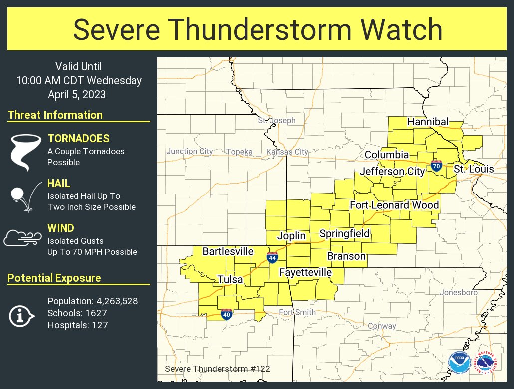
2:30 a.m. UPDATE: The National Weather Service has expanded the Severe Thunderstorm Watch to include all of southwest Missouri until 10:00 a.m. Ozark and Howell Counties to the southeast of Springfield are now under a Tornado Watch until 9:00 a.m. Wednesday.
2:15 a.m. UPDATE: The Severe Thunderstorm Warning for Vernon County has been extended until 3:00 a.m.
1:37 a.m. UPDATE: The National Weather Service has issued a Severe Thunderstorm Warning for Vernon County until 2:15 a.m. 60 mile per hour winds and quarter size hail will be possible with this storm as it moves into the Nevada area.
1:35 a.m. UPDATE: The National Weather Service has issued a Tornado Watch until 9:00 a.m. Thursday for Ozark and Howell Counties. Conditions are favorable for the development of tornadoes.
12:07 a.m. UPDATE: The National Weather Service has issued a Severe Thunderstorm Watch for areas west of Springfield until 5:00 a.m. Wednesday. Counties included in the watch are Barton, Cedar, Dade, Hickory, Jasper, Newton, Polk, St. Clair and Vernon.
8:50 p.m. UPDATE: The National Weather Service says the cap that is preventing storms from breaking out is holding strong. Nevertheless, there remains a conditional threat for severe storms (if the cap can break) ahead of an expected squall line of storms late Tuesday night into early Wednesday morning. If storms can manage to develop ahead of the squall line, which has developed across eastern Kansas, they would likely be severe. The squall line will get into the northern portions of the I-49 corridor (near Nevada) between midnight and 2 a.m. Wednesday. Joplin would be more in the 2 a.m.-4 a.m. time frame. It should then reach the I-44 corridor around Lebanon and Springfield in the 3 a.m.-5 a.m. time frame.
Original Story: Strong nighttime tornadoes are a risk for a large part of the Ozarks Tuesday night into early Wednesday morning, including the Springfield metro area.
The National Weather Service says confidence is increasing that areas along and east of a line from Springfield to Branson may have at least a few strong tornadoes of EF-2 strength or above.
This area is in a “moderate,” or level 4 risk for severe weather, which also includes the potential for up to tennis ball size hail during the evening into the overnight hours.
Forecasters say there is some degree of uncertainty on a cap of warm air aloft that could limit thunderstorm updraft development.
The entire area has the potential for damaging winds up to 70 miles per hour, especially as a line of storms moves through southwest Missouri during the overnight hours.
The National Weather Service timeline for severe storms shows the greatest threat after 10 p.m. Tuesday night, continuing past 4 a.m. on Wednesday.
In addition, gusty winds are possible through Tuesday night outside of any thunderstorms, with a Wind Advisory in effect at 2:00 p.m. and going through 1:00 a.m. Wednesday.
Wind gusts of 35 to 50 miles per hour are expected, with the highest gusts west of Highway 65.
We’ll have the latest forecast changes and severe weather watches and warnings at 93-3 A-M 560 KWTO.