7:00PM UPDATE: National Weather Service radar UPDATE: Overall, snowfall rates have decreased from earlier in the afternoon. However, a few narrow bands of moderate snow still persist. The snow is still on track to end from west to east between 10pm-6am.
6:00PM UPDATE: Springfield Police say both westbound lanes are back open on westbound I-44 west of Highway 65 after being closed due to multiple crashes.
6:00PM UPDATE: More snow totals: 5 inches between Halltown and Mt. Vernon, 5.5 inches on the north side of Joplin/Webb City, 5.25 inches west of Goodman (McDonald County), 5.0 inches in Galloway (Greene County), 5.0 west of Halltown, 5.5 inches in Joplin, 3.3 inches in Houston, 8.0 inches off T Highway in Taney County, 6.0 inches in Forsyth, 3.5 inches in Rolla, 6.0 inches at Highway 376 and 76 Country Boulevard in Branson, 6.5 inches in Iberia.
5:30PM UPDATE: Westbound traffic on I-44 ix closed at Exit 82A. All westbound traffic is being diverted south onto Highway 65.
5:30PM UPDATE: More snow totals: 3.0 inches in Marshfield, 4.0 inches in Ozark, 3.5 inches in Ava, 4.0 inches in Neosho, 3.0 inches in Springfield at the Greene County Public Safety Center. Also, 3.0 inches in east Springfield.
5:30PM UPDATE: From Pulaski County Emergency Management: Multiple crashes on I44 by mile marker 142 and 143. Westbound by exit 145 has been closed down.
4:10PM UPDATE: MODOT has closed westbound I-44 near Highway 65 in Springfield following multiple crashes. The wrecks happened in the westbound lanes of the interstate around 3:45pm on Tuesday. It could take several hours to re-open the interstate.
4:00PM UPDATE: MoDOT has closed the westbound lanes of I-44 near mile marker 144 between Lebanon and Waynesville due to multiple crashes. MoDOT reported the interstate was snow-covered at the time of the crashes. Traffic is being diverted at mile marker 145.
3:30PM UPDATE: More snow totals: 5.0 inches in Carthage, 4.0 inches in Cassville, 2.8 inches in Buffalo, 3.5 inches in Hollister
3:15PM Radar UPDATE from National Weather Service: Another band of moderate to heavy snow is moving into Jasper County and Joplin now, with rates around 1″/hr in Taney County. The heaviest band currently is set up from Bates to Benton county moving east.
2:17PM UPDATE: From the Missouri Department of Transportation: Due to extreme weather and multi-vehicle crashes on the Oklahoma Turnpike, westbound Interstate 44 is CLOSED at mile marker 11 near the Missouri-Oklahoma state line for an extended and unknown duration. The Missouri Department of Transportation recommends all drivers seek an alternate route or prepare to stop and seek shelter. The final opportunity to exit from westbound I-44 will be at Exit 11, where drivers can exit to the north to Missouri Route 249 or south to I-49.
2:15PM UPDATE: New snow totals coming in: 3.5 inches in Joplin, 1.5 inches in Ava, 3.0 inches in Neosho, 3.0 inches in Carthage, 2.3 inches in St. Robert, 2.5 inches in Marshfield, and 3.0 inches in Ebenezer (Greene County). 1.5 inches were reported in Ash Grove at 1:15pm and 2.5 inches in Warsaw at 1:15pm. Just after 1:00pm, we had reports of 4.0 inches of snow on the ground north of Taberville (St. Clair County).
1:26pm UPDATE: Joplin police reporting multiple slide-offs on I-44 in the Joplin area, including semis.
11:10AM UPDATE: Westbound I-44 is closed at exit 29 La Russell/Sarcoxie exit due to a multi-vehicle pileup Also, traffic is being diverted at the Oklahoma/Missouri state line due to westbound I-44 being closed due to crashes in Oklahoma.
11:00AM UPDATE: From the National Weather Service: Visibilities are being reduced to 1/4 to 1 mile within the heavier snow bands developing out west. Wind gusts out west are also 25-30 mph. This is near blizzard-like conditions. It would “officially” be blizzard-like with gusts up to 35 mph and visibilities consistently below 1/4 mile. But with 5-10 mph off, it doesn’t change things too much. Accumulations are occurring rapidly on roads, with reduced visibilities akin to dense fog, and moderate wind gusts. This will continuously make driving conditions hazardous through today and this evening. The worst is still expected this afternoon/evening.
Other snow updates from across the Ozarks being reported to the National Weather Service:
2.0 inches of snow reported in Bois d’Arc (1:39pm)
2.5 inches of snow reported in Joplin (12:49pm)
1 inch of snow reported in Ava (12:43pm)+
Snow is getting heavier in Barton County. The courthouse has closed. The City of Lamar is closing City Hall at 1pm (12:26pm)
About 3 inches of snow on the ground at Cross Timbers (Hickory County)
Roads getting covered in Marshfield (10:48am)
Roads are snow covered in Shell Knob (10:44am)
Roads are being quickly snow-covered in Joplin (10:40am)
1.5 inches of snow reported in Camdenton (9:50am)
Heavier snow bands in Joplin and Webb City (Reported at 9:49am)
Roads are snow covered in Dade County (Reported at 9:15am)
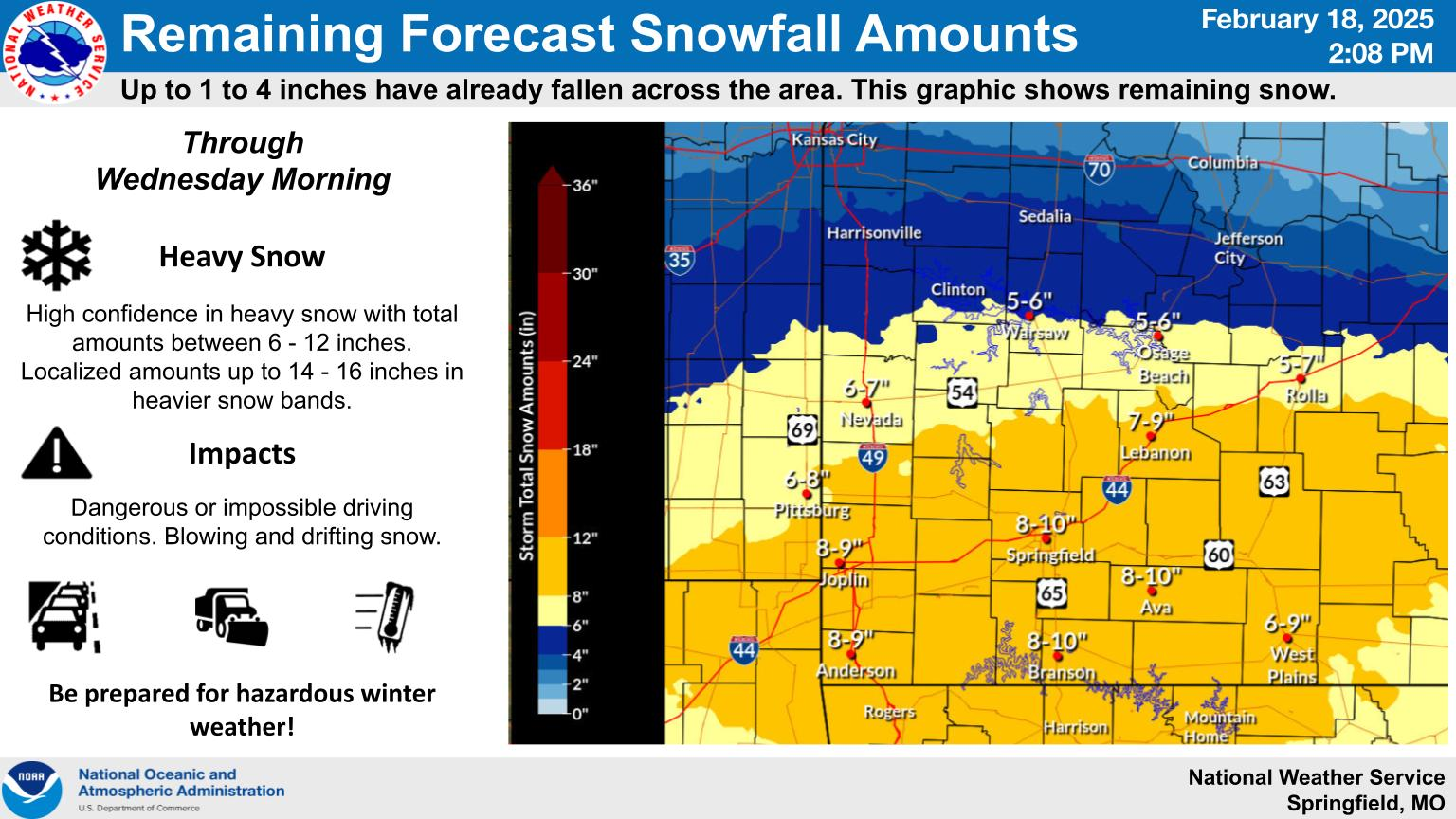
Original Story: Heavy snow is expected in the Ozarks from late Tuesday morning through the afternoon and evening hours before winding down early Wednesday morning.
The National Weather Service says 8 to 12 inches of snow are possible in the Springfield, Branson and Joplin areas, with lesser amounts of 5 to 8 inches in the far northern Ozarks around Clinton, Warsaw and Osage Beach.
As of 7:15am, the MoDOT Traveler Information map was already showing snow covered roads north of Springfield along Highway 13 and Highway 65, west of Springfield along I-44 and I-49 and northeast of Springfield on I-44.
Forecasters say major impacts are anticipated across much of southwest Missouri, with considerable disruptions to daily life or even impossible driving conditions by Tuesday evening through the nighttime hours.
Blowing and drifting of snow will also create dangerous impacts for travelers.
A Cold Weather Advisory is in effect from 6pm Tuesday through 12pm Thursday, with a high confidence in dangerous cold through Friday morning. Wind chills of -10 to -20 are likely during this period.
By 6:35am Tuesday, we had reports of 1 inch of snow in the Stockton area, with city streets and secondary highways in the Lebanon area snow covered.
by 7:15am, roads were partially covered between Joplin and Neosho, and Highway 5 north of Lebanon was becoming snow-covered by 6am.